- Home
- History of India
- Ancient India
- Ancient India Geography
Ancient India Geography
Updated 11-05-2020
Ancient India Geography:
The geography of India
is diverse landscape, snow capped mountains, deserts, plains, hills and
plateaus. India got its name from the River Indus. The geography of India is
not much different now as compared to ancient times. To the north of India is
the mighty Himalayas and the Hindu Kush mountains in the North West which
protect us from the cold polar winds.
The Southern part of India is plateau which is surrounded by seas and ocean on three sides. The Arabian Sea is to the South West, The Indian ocean is on the southern side and the Bay of Bengal on the South East of India.
Ancient India was very rich in natural resources due to topography of the country. India grew crops like cotton, barley seasame, rice and many other things along with vegetables and fruits. One of the most important River during ancient period was Indus river were in some of the major civilisations flourished on the banks of this River.
India is a vast country. During ancient period many countries surrounding India were part of India. The climatic conditions were very favourable to agriculture because of no pollution in ancient period. During this period there were two main civilizations known as Indus valley civilization and Vedic civilisation.

The Indus valley civilisation flourished on Indus River. Since, land was very fertile during ancient period many small villages cropped up along the river basin for cultivation. The water drainage system during Indus valley civilisation provided an excellent opportunity for improvement of trade and commerce. Farming was one of the major occupation during the ancient period.
Along with River Indus another River is River Saraswati became a very important river for the growth and civilization during the ancient period. Many crops were grown along the river belts like the cotton, seasame, rice and Barley.

In the ancient
period India had a very large land mass which included the present Pakistan,
Afghanistan, Burma, and Bangladesh. The Himalayas which act as a barrier and
protect the Northern part of India were also present during ancient India.
There were many rivers which are even mentioned in the holy books of Vedic
civilisation.
The Northern part of India has the huge Himalayan mountains and the Hindu Kush Mountains stand in the North West. The Southern Part of India which is known as Deccan plateau is surrounded by three seas namely Arabian sea to the South West, Indian ocean on the Southern side and the Bay of Bengal is towards the South East
Some of the important rivers that were mentioned are Indus, River Sindhu, Gomati, Ganga, Yamuna, and Saraswati. River Saraswati which was very famous is not seen in the present India.
These rivers were ideal place for cultivation. India
got its name from river Indus. These rivers are very huge in size and the land
near these rivers is very fertile. Most of these rivers get water from the
Himalayas.
The Indo Gangetic plains produced crops like wheat and barley while the middle Gangetic plain produced rice. During the ancient times rivers also served as means of communication and trading.
Rivers were also acted as barriers between two kingdoms and also acted as political boundaries during ancient period.
But however during the heavy floods many cities that were built along the banks of the rivers would get washed away causing huge loss to life and economy. Some of the ancient cities that were built along the banks of the rivers include Hastinapur, Varanasi, Prayag
Civilisation during Ancient India Geography
Many civilisations that flourished during ancient period. Some of the important civilisations are Harappa and Mohenjo daro, Indus Valley Civilisation. Dolavira and Lothal are some of the important ancient sites which flourished during ancient period. Harappa civilisation is considered as one of the best civilisations.
Some major Characteristics during this civilisation was that it was a very well planned city. the water drainage system was very neatly done. It had proper roads and well maintained public utility system.
Climate and Monsoon in Ancient India Geography
The Indian subcontinent had a very good climatic conditions and had very good monsoon season due to it location. The South West Monsoon lasts from June to October brings rain to most part of the country. Climatic conditions very suitable during ancient period for farming and growing of different crops during different seasons.
Due to good climatic conditions food was grown in excess which resulted in the development of irrigation and agriculture. Climate across India varies from equatorial in the South to Alpine and tundra in the Himalayas
Climatic conditions during ancient period was much better and no pollution as compared to today. Indian subcontinent is mostly situated in the Tropical zone with the mighty Himalayas in the North protect India from cold artic winds. Even during ancient India basically enjoyed three seasons Summer, Monsoon and Winter season.
Summer season: From March to May. In Northern part of India May is the hottest month while in Southern and Western region April is the hottest month.
Monsoon season: June to September were monsoon season
November to February: Winter Season. Winters are harsh in Northern part of India while it is mild in Southern part of India.
Even though India has extreme geological and climatic conditions are different at different parts of the country still it was a great asset for the country for the development since ancient time.
Rivers in Ancient India geography
The Indus Gangetic
plane was very fertile and produced rich crops like wheat, barley and the lower
Gangetic plane produced rice. The Indus River had five tributaries namely River Sutlej, River Chenab, River Beas, River Ravi and River Chenab.
The Ganga Brahmaputra Plain lies towards the South of Himalayas is one of the most fertile plain since ancient times. Indus River was one of the most important River in the ancient times. Many civilisations started along the banks of this river.
The geography of India is very interesting. It consists of rivers, mountains, desert, land and forest. The southern part of India even in ancient period was covered by three side Sea. It is called as Deccan plateau. The seas are Arabian sea towards the west, the bay of Bengal towards east and Indian ocean towards south.
There are certain changes in the geography of present India. Some of the parts have become independent countries. Please share your thoughts with us by clicking the link here.
Update on coronavirus in India
Affiliate Disclosure:
If you make any purchase via a link on this site, I may receive a small commission with no added cost to you.
Check here for Beautiful designer wear Designs
Recent Articles
-
Agumbe --- |Karnataka| | Waterfalls| |Western Ghats |Tourism|
Mar 31, 25 05:56 AM
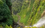 Agumbe is a beautiful serene village located in west coastal region in Shimoga district,Thirthalli taluk in Malnad region of Karnataka, India.
 -
Belur Chennakeshava temple, Karnataka, India
Mar 31, 25 05:53 AM
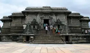 Belur is world famous for the Chennakeshava temple built during Hoysala period. Belur is also known as Velapura
 -
Badami Cave Temples, History, How to Reach, Best Time to Visit
Mar 31, 25 05:48 AM
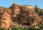 Badami is located in Bagalkot district of Northern part of Karnataka. The place is world famous for the cave temples built during the Chalukya period.
Reach us on and share your feed back on
contact us
Popular pages
Indian art, Indian architecture, Religions of India, culture of India, History of India, Tourism in India, Yoga, ancient India, Indian Music, Indian Dance, India Independence Movement, Indian Dynasties, Ayurveda, Indian Folktales, Geography of India, National Parks in India, National Symbols of India