- Home
- Geography of India
Geography of India
Geography of India
Here are the quick links to check within the page
India is a vast country. It is a geographically rich and a diverse country. India has all the geographical factors like the deserts, coastal areas, plateaus and the mountains. It is very interesting to read and understand the geography of the second most populous country in the world.
India lies entirely in the Northern Hemisphere between 8°4'N and 37°6'N and longitudes 68°7'E and 97°25'E. The Tropic of Cancer (23° 30'N) divides India into almost two equal parts. India occupies a large part of South Asia and is one of the important countries in the world. New Delhi is the capital of India. With total area of 3,287,263 square kilometres, India is the seventh largest country in the world
The landmass of India has an area of 3.28 million square kilometre. Having a coastline line of 7000 Km makes most part of India lie on a peninsula in Southern Asia. India is surrounded by Arabian sea in the southwest, Bay of Bengal in the South east and Indian Ocean in the south.
Update on coronavirus in India
Relief- Geography of India
 image credit--en.wikipedia.org
India lies on the Indian Plate. Indian Plate is a tectonic Plate which was originally a part of Gondwana. After Indian Plate broke from Gondwana it started to move north about 100 million years ago. The Indian plate started moving north and fused with Australia Plate to form a single Indo Australian plate. The collision of the plate with the Eurasian plate led to the formation of lofty Himalayas.
Also the collision with the Eurasian plate along the border of India and Nepal formed the orogenic belt which formed the Tibetean Plateau and Himalayan Mountains. Recent studies suggest that the Indo Australian plate may have broken into many smaller plates due to the collision with the Eurasia Plate.
Due to the continuous rapid erosion of Himalayas there was a lot of accumulation of sediments which were carried by the mountain streams to different zones.
Boundaries of India
India shares its land borders with China, Pakistan, Afghanistan, Nepal and Bhutan in the North and North or North west, Bangladesh and Myanmar in the east. India further shares water borders with Srilanka, Maldives, Thailand and Indonesia.
Climate of India
India has a unique geography due to which it experiences a wide range of weather conditions across the country. The northern part of India experiences extreme climate both in summer and winter while the South India experiences mild climate through most part of the year with few exceptions. It can be said that weather is the conditions of the atmosphere for over a short period of time while the climate is how the atmosphere behaves for a very long period of time. Weather can change for every minute but not the climate.
Some of the major factors that influence climate in India are the Latitudes, The Himalayan Mountains, The Thar Desert, Altitude, relief and distribution of land and water.
According to the Koppen system India experienced all the six major climatic subtypes. Basically the four seasons of the country are Summer, Rainy, Winter and post monsoon season along with spring and autumn season.
Summer seasons are the months of April, May and June, Winter are January and February, Rainy/Monsoon season are from June to September and post monsoon season is from October to December.
The Thar desert in the northwest and the Himalayas in the North work together to develop the important monsoon season. The Himalayas act as a barrier and protect the Northern Part of India from the icy cold winds. Even though the Tropic of cancer passes through the middle of India, the whole country is regarded as tropical.
India experiences different climatic regions like the tropical in the south to alpine and temperate in the North and the thar desert in the north west. The Thar desert brings the moisture laden South west monsoon winds between June and October which provides major rainfall in India.
Seasons:
Summer season: The summer season in India lasts from March to June in most parts of the country. In most parts of North India the maximum temperatures could go up to 45 degree celsius. The temperature in thar desert could go above 45 degree celsius. Even though the temperature may not go above 40 in coastal areas, there would be a lot of humidity in these places. May and June are the hottest months in North India.
Monsoon Season:
Monsoon season lasts from early June to September. The southwest monsoon enters South India through Kerala by mid May and moves towards Karnataka, Maharashtra then covers the entire country by July.
The southwest monsoon can be split into two parts, the Bay of Bengal part and the Arabian sea part. The Bay of Bengal part moves towards northeast India by early June and the Arabian sea deposits much of its rain in Western Ghats.
South India receives more rainfall than North India. Most parts of the country remain very humid during the monsoon season. Monsoon starts retreating by early October from the country. Most parts of Tamil Nadu remains dry during monsoon season as it is parallel to Bay of Bengal. It receives rain during November and December.
Winter season:
Winter season occurs from November to March in most parts of the country. The coldest months are December and January. The North part of India experiences extreme cold conditions while the peninsular India experiences mild cold. The minimum temperature may go sub zero levels in most parts of North India. The western disturbance brings in a lot of rain and snow in North India. Eastern part of India enjoys a milder winter climate with temperature hovering around 29-10 degrees.
The spring season starts from March to April. The weather remains pleasant and comfortable during these months.
Physical features of India
Based on the physical features India is broadly divided into six physical regions:
- The Northern Mountains
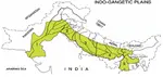
- Indo Gangetic plains- The Northern Plains
- Peninsular Plateau
- Thar Deserts
- Coastal Plains
- Islands

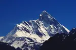
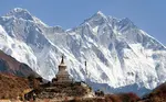
Northern Mountains: Himalayas:
One of the youngest and most breathtaking mountain ranges is the Himalayan mountain range It covers almost 11 Indian states and union territories. The Himalayas extend from Jammu Kashmir in the north to Arunachal Pradesh in the East. The Himalayan ranges include the Greater Himalayas (Himadri), Lesser Himalayas (Himalaya Range), Outer Himalaya( Shiwaliks). The Himalayas act as a barrier and protect north India from the cold winds. Read more on the Himalayas.
The Northern Plains or the Indo Gangetic plain also known as the great plains are covered with alluvial soil that are deposited by the three main rivers namely Ganga, Brahmaputra and Indus. These plains got the name as Indo Gangetic plains because of the rivers Indus and Ganga. The northern plains are divided into four divisions namely
The Bhabar belt-- It is just adjacent to the foothills of Himalayas
The Tarai belt---is towards the south of bhabar belt and consists of new alluvium
The Bangar belt----it consists of older alluvium along the river forming the terraces higher than the floodplain. It is rich in humus content and dark in color.
The Khadar belt--- composed of newer alluvium and forms flood plains along the rivers banks. It is usually found near the river beds.
Some of the most important crops grown in this region include rice,wheat, maize, sugarcane and cotton. The Indo Gangetic Plain is one of the most densely populated areas in the world.
Peninsular Plateau
Peninsular plateau :
The Peninsular plateau is formed due to the breaking up of the Gondwana land forming it as one of the oldest land masses. The peninsular plateau can be divided into three groups namely 1) central Highlands, The Deccan Plateau, The Northeastern Plateau.
The peninsular plateau has broad and shallow valleys surrounded by Hills. The part of the Peninsular Plateau which is towards the north of Narmada river is known as Central Highlands. It covers a large part of Malwa Plateau. The Vindhya range is bounded by Satpura range on the south and Aravalis on the northwest. The central Highlands are wider towards the west and narrower towards the east.
The Deccan Plateau lies towards the south of Narmada river and is shaped as an inverted triangle. The Deccan Plateau is higher in the west and slopes gently eastwards. The plateau is Located between two mountain ranges, the Western Ghats and the East Ghats. One of the most important distinct features of the Peninsular Plateau is the black soil area known as Deccan Trap.
The Northeastern Plateau consists of the Meghalaya Plateau and the Rajmahal Hills. The Meghalaya Plateau is further divided into Ghro Hills, Khasi Hills and Jaintia Hills. Shillong is the highest point of the plateau.
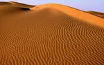
The Indian Desert lies towards the northwestern of Aravalis. The thar desert which is also known as the great Indian Desert covers an area of 77,000 sq mi and acts as a natural boundary between India and Pakistan. It has a dry climate with low vegetation. Water is scarce as rainfall is erratic. The soils of arid regions are usually sandy loam in texture. The summers are very hot and the temperature may go up to 50 degree celsius and in winters temperature may go upto zero degree celsius.
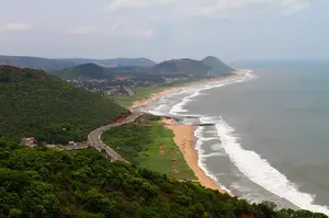
The coastal plain is divided into eastern coastal plain and western coastal plain. The western coast is a narrow plain between Western Ghats and Arabian sea. It consists of three sections- The northern part is the Konkan coast, the southern stretch is the Malabar coast and finally the central stretch is the kannad plain. The western coastal plain extends from Gujarat in the north and covers states like Maharashtra, Goa, Karnataka and Kerala.
The Eastern coastal plain stretches from Eastern Ghats and Oceanic boundary of India. It stretches from Tamil Nadu in the South to West Bengal in the east. The eastern coastal plain along the northern part is known as northern circars while the southern part is known as coromandel coast. Large rivers like Krishna, Godavari, Kaveri have formed delta along the coromandel coast.
Islands:
Lakshadweep and Andaman and Nicobar Islands are the two major Islands of India. Kavaratti island is the administrative headquarters for Lakshadweep. The island is known for beautiful flora and Fauna and corals. Lakshadweep is located off the coast of Kerala in Arabian sea. It consists of around 35 Islands and islets.
Andaman and Nicobar Islands consists of 572 islands out of which 38 are inhabited. Port Blair is the capital city. Read more on these Islands.
Drainage System
Drainage System:
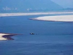
India is a country of rivers. More than 400 rivers are there in India. The Indian drainage system consists of both small and big rivers. The drainage system in India is grouped into two groups namely the Arabian sea drainage and Bay of Bengal drainage. More than 70% drains into Bay of Bengal and the remaining drains into Arabian sea. The rivers like Ganga, Brahmaputra, Krishna, Mahanadhi drain into the Bay of Bengal along the Ganga Brahmaputra river system. And around 20% comprises Indus, Tapi, Narmada and Mahi drain in Arabian sea.
On the basis of origin and nature the Indian drainage is classified into two different categories namely
The Himalayan drainage and the Peninsular drainage.
Most of the Himalayan rivers are perennial which means they have water throughout the year and are not just dependent on rains. These rivers get water from not only rain but also from the melted snow from the Himalayas. Major rivers in Himalayan include Indus and Brahmaputra.
The Peninsular rivers are mostly dependent on rain for water. The major rivers like Mahanadhi, Krishna, Godawari and Kaveri drain into Bay of Bengal. These rivers make deltas at their mouth.
The major drainage pattern include:
Dendritic, Radial, Centripetal, Trellis.
Soil:
Soil is a very important natural resource for human beings. Soils in India can be classified into eight different categories. Alluvial, black, red, Laterite, forest, arid, forest and mountainous soil. These soils are the mixture of organic debris and are rich in chemical ingredients. Major constituents of the soil include humus, water and air.
Alluvial soil constitutes the largest soil in India. Alluvial soil is generally fertile but does not contain nitrogen. Black soil is found in the Deccan region of Maharashtra, Gujarat and Madhya Pradesh. It contains more clay and moisture in it.
Red soil is formed on the igneous rock and is found in eastern and southern parts of the Deccan plateau. Arid soil is generally saline in nature. Forest soils are found on the slopes of the mountains.
Natural vegetation of India:
India is gifted with a wide range of flora and Fauna. Natural vegetation grows naturally and is different due to different climatic conditions across the country. Due to varied climatic conditions India is gifted with a wide range of natural vegetation. Vegetation in India can be divided into five different categories
- Tropical Evergreen and Semi Evergreen forests
- Tropical Deciduous forests
- Tropical Thorn forests
- Montane forests
- Mangroove Forest.
Rivers of India
Rivers of India:
Rivers are the lifeline of the people across the world. In India rivers are considered as God and Goddess. There are many uses from the rivers like the electricity, transportation, potable drinking water and many more. India is blessed with many rivers across the country. Some of the major rivers are Indus, Ganga, Brahmapura, Kaveri, krishna, Godavari….. many more. All major rivers originate from one of the following watersheds
Aravalli range
Himalaya and Karakoram range
Sahyadri in western India
Vindhya and Satpura range.
The Himalayan glaciers are further divided into three basins, Ganga, Brahmaputra and Indus basin. These basins have thousands of glaciers and Ganga is the largest river system in India. The Western Ghats and the monsoon rains are the source of water for the Deccan rivers which include Krishna, Kaveri, Godavari.
Biosphere Reserves of India
Also read more on the National parks in India
Biosphere reserves of India:
Biosphere reserves are the large areas of land where flora and fauna are protected. It is a large area of natural habitat. Biosphere reserves include more than one national park. India has 18 biosphere reserves. Out of which 12 are part of the World Network of Biosphere reserves which is based on the UNESCO's man and biosphere programme list.
The 18 biosphere reserve of India are Nilgiri Biosphere Reserve, Gulf of Mannar, Sunderbans Biosphere, Nanda Devi , Nokrek Biosphere, Pachmarhi Biosphere, Similipal Biosphere, Great Nicobar Biosphere, Achanakmar-Amarkantak Biosphere, Agasthyamalai Biosphere, Khangchendzonga National Park, Panna, Manas, Seshachalam Hills, Dihang-Dibang, cold desert, Great Rann of Kutch, Nanda Devi, Dibru-Saikhowa.
You might like these
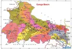
Ganga Basin - Ganga River,Climate, Pollution, Pilgrimage places
Ganga basin or Ganges basin is the part of the Ganga Brahmaputra basin draining around 1,086,000 square Kilometres in Tibet, Nepal, India and Bangladesh.
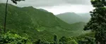
Western Ghats--Highest Peak,Geography, Rivers, Flora and Fauna
Western Ghats is the longest mountain ranges that run parallel to the western coast of India. The Ghats covers the state of Kerala, Karnataka, Tamil Nadu, Goa, Maharashtra and Gujarat
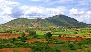
Deccan Plateau --Climate, History, Deccan traps,Tourism
Deccan Plateau is a large plateau that covers most parts of Southern India between Western and Eastern Ghats
Kamet peak. | Trisul Peak |Shivling Peak |Chaukambha Peak|
Kamet is the second highest mountain peak of the Himalayas located in the Garhwal region of Uttarakhand, India
Thar Desert -- Climate, Vegetation, Flora and Fauna, Tourism
Thar desert also known as the Great Indian Desert is located in the Indian subcontinent. It is a dry arid region.
Indo-Gangetic Plain --Bhabar, Tarai, Khadar and Bangar Belt
Indo-Gangetic Plain also known as Indus Ganga Plain consists of alluvial soils which are deposited by the rivers Indus, Ganga and Brahmaputra.
Nanda Devi - |Location, National Park, How to Reach |
Nanda Devi is the second highest peak in India. It is located in Gharwal Himalayas, Uttarakand. Nanda Devi is 23rd highest peak in the world
Eastern Ghats -- Geography, Hill Ranges, Climate
Eastern Ghats are discontinuous mountain range along the eastern coast of India. They run parallel to Bay of Bengal.
Himalayas in India- Location, Physical Features, Climate
Himalayas in India are the youngest mountain range is the world. Himalayas separate Indian sub continent from Tibet and rest of Asia
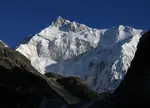
Kanchenjunga Peak -The Third Highest Peak in the World
Kanchenjunga is the third highest peak in the world. It lies partly in Nepal and partly in Sikkim.Kanchenjunga is also known as five treasures of snow
Coastal Plains of India --Eastern and Western Coastal Plain.
The coastal plains of India run on both the sides of the peninsular plateau along the eastern and western coasts of India.
Brahmaputra River Basin
Brahmaputra river basin. In India the river covers the states of Assam, Arunachal Pradesh, Nagaland, West Bengal and Meghalaya.

Affiliate Disclosure:
If you make any purchase via a link on this site, I may receive a small commission with no added cost to you.
Check here for Beautiful designer wear Designs
Recent Articles
-
Agumbe --- |Karnataka| | Waterfalls| |Western Ghats |Tourism|
Mar 31, 25 05:56 AM
 Agumbe is a beautiful serene village located in west coastal region in Shimoga district,Thirthalli taluk in Malnad region of Karnataka, India.
 -
Belur Chennakeshava temple, Karnataka, India
Mar 31, 25 05:53 AM
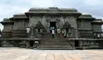 Belur is world famous for the Chennakeshava temple built during Hoysala period. Belur is also known as Velapura
 -
Badami Cave Temples, History, How to Reach, Best Time to Visit
Mar 31, 25 05:48 AM
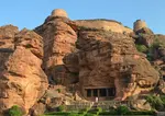 Badami is located in Bagalkot district of Northern part of Karnataka. The place is world famous for the cave temples built during the Chalukya period.
Reach us on and share your feed back on
contact us
Popular pages
Indian art, Indian architecture, Religions of India, culture of India, History of India, Tourism in India, Yoga, ancient India, Indian Music, Indian Dance, India Independence Movement, Indian Dynasties, Ayurveda, Indian Folktales, Geography of India, National Parks in India, National Symbols of India