- Home
- Geography of India
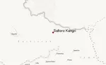
- Brahmaputra River Basin
Brahmaputra River Basin

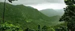
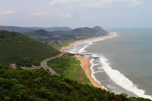
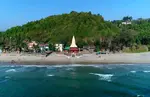
Brahmaputra river Basin: The Ganga and Brahmaputra basin is situated in the northern part of Indian sub continent. The basin consists of two large rivers Ganga and Brahmaputra. Brahmaputra basin covers countries like Tibet, Bhutan, India and Bangladesh. The basin of Brahmaputra river is 651334 Km2. In India the river covers the states of Assam, Arunachal Pradesh, Nagaland, West Bengal and Meghalaya. During the monsoon season the basin receives highest rainfall causing floods in the state of Assam. The upper part of the basin lying in Arunachal Pradesh and Nagaland are beautiful valleys and mountain ranges.
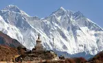
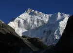
Brahmaputra River is one of the largest rivers in the world. The river originates in Angsi Glacier in Tibet. The glacier is located on the northern side of the Himalayas. In Tibet the Brahmaputra River is known as Yarlung Tsangpo. It is slightly bigger longer than the river Indus. Most of the path or the course of Brahmaputra River lies outside India. On reaching Namcha Barwa the river takes a U turn and enters India through Arunachal Pradesh.
In Arunachal Pradesh it is called as Siang and later it is joined by rivers like Dibang, Lohit and some other tributaries the form Brahmaputra in Assam. As the Brahmaputra river flows in the valley it is joined by many streams that come from the Himalayas like Subansiri, Kameng, Bhareli, Manas, Sankosh River. Between Dibrugarh and Lakhimpur Districts, the river splits into two channels known as Northern Kherkutia and southern Brahmaputra channel. The two channels join again to form Majuli Island which is the largest river island in the world. Some of the important tributaries of Brahmaputra River are Tsang-po, Jamuna and Teesta River.
Climate in Brahmaputra River Basin

The climate in the Brahmaputra basin is quiet similar to Ganga basin. There are basically three seasons in the Brahmaputra Basin that is summer, winter and Monsoon. The climate of the Brahmaputra basin is affected by various factors like the winds from the local mountains and valleys, alternating pressure cells of NE India and Bay of Bengal and the tropical air mass. Summers are hot and dry.
Monsoon receives heavy rainfall causing flood and winters are cold. Urbanisation and deforestation in Brahmaputra basin has led to increase in deposit of silt, soil erosion. During the monsoon season the kaziranga national park in Assam usually gets submerged from floods. Massive flooding also causes heavy loss of life, property and financially to the government of Assam.
Because of flooding lot of health related issues comes up. Paddy, wheat, Shorgum and millets are some of the important crops grown in this basin. The river has huge silts deposited on the bed causing river bed to rise. The type of soil found in the basin is the red loamy soil and alluvial soil. Some of the other important types of soil found are sandy, loamy, clayey soil and their combinations.
Update on coronavirus in India
You might like these
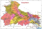
Ganga Basin - Ganga River,Climate, Pollution, Pilgrimage places
Ganga basin or Ganges basin is the part of the Ganga Brahmaputra basin draining around 1,086,000 square Kilometres in Tibet, Nepal, India and Bangladesh.
Western Ghats--Highest Peak,Geography, Rivers, Flora and Fauna
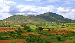
Western Ghats is the longest mountain ranges that run parallel to the western coast of India. The Ghats covers the state of Kerala, Karnataka, Tamil Nadu, Goa, Maharashtra and Gujarat
Geography of India -- Climate, Boundaries, Facts, Plateau
Geography of India- India has all the geographical factors like the deserts, coastal areas, plateaus and the mountains.
Deccan Plateau --Climate, History, Deccan traps,Tourism
Deccan Plateau is a large plateau that covers most parts of Southern India between Western and Eastern Ghats
Kamet peak. | Trisul Peak |Shivling Peak |Chaukambha Peak|
Kamet is the second highest mountain peak of the Himalayas located in the Garhwal region of Uttarakhand, India
Thar Desert -- Climate, Vegetation, Flora and Fauna, Tourism
Thar desert also known as the Great Indian Desert is located in the Indian subcontinent. It is a dry arid region.
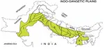
Indo-Gangetic Plain --Bhabar, Tarai, Khadar and Bangar Belt
Indo-Gangetic Plain also known as Indus Ganga Plain consists of alluvial soils which are deposited by the rivers Indus, Ganga and Brahmaputra.
Nanda Devi - |Location, National Park, How to Reach |
Nanda Devi is the second highest peak in India. It is located in Gharwal Himalayas, Uttarakand. Nanda Devi is 23rd highest peak in the world
Eastern Ghats -- Geography, Hill Ranges, Climate
Eastern Ghats are discontinuous mountain range along the eastern coast of India. They run parallel to Bay of Bengal.
Himalayas in India- Location, Physical Features, Climate
Himalayas in India are the youngest mountain range is the world. Himalayas separate Indian sub continent from Tibet and rest of Asia
Kanchenjunga Peak -The Third Highest Peak in the World
Kanchenjunga is the third highest peak in the world. It lies partly in Nepal and partly in Sikkim.Kanchenjunga is also known as five treasures of snow
Coastal Plains of India --Eastern and Western Coastal Plain.
The coastal plains of India run on both the sides of the peninsular plateau along the eastern and western coasts of India.
Affiliate Disclosure:
If you make any purchase via a link on this site, I may receive a small commission with no added cost to you.
More touristic places
Himalayas in India
Mount Everest
Kanchenjunga
Nanda Devi
Kamet Peak
Ganga Basin
Brahmaputra River Basin
Western Ghats
Eastern Ghats
Deccan Plateau
Check here for Beautiful designer wear Designs
Recent Articles
-
Agumbe --- |Karnataka| | Waterfalls| |Western Ghats |Tourism|
Mar 31, 25 05:56 AM
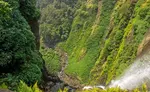 Agumbe is a beautiful serene village located in west coastal region in Shimoga district,Thirthalli taluk in Malnad region of Karnataka, India.
 -
Belur Chennakeshava temple, Karnataka, India
Mar 31, 25 05:53 AM
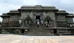 Belur is world famous for the Chennakeshava temple built during Hoysala period. Belur is also known as Velapura
 -
Badami Cave Temples, History, How to Reach, Best Time to Visit
Mar 31, 25 05:48 AM
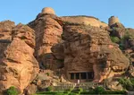 Badami is located in Bagalkot district of Northern part of Karnataka. The place is world famous for the cave temples built during the Chalukya period.
Reach us on and share your feed back on
contact us
Popular pages
Indian art, Indian architecture, Religions of India, culture of India, History of India, Tourism in India, Yoga, ancient India, Indian Music, Indian Dance, India Independence Movement, Indian Dynasties, Ayurveda, Indian Folktales, Geography of India, National Parks in India, National Symbols of India