- Home
- Geography of India
- Himalayas in India
- Mount Everest
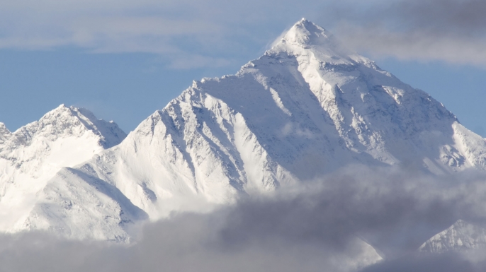
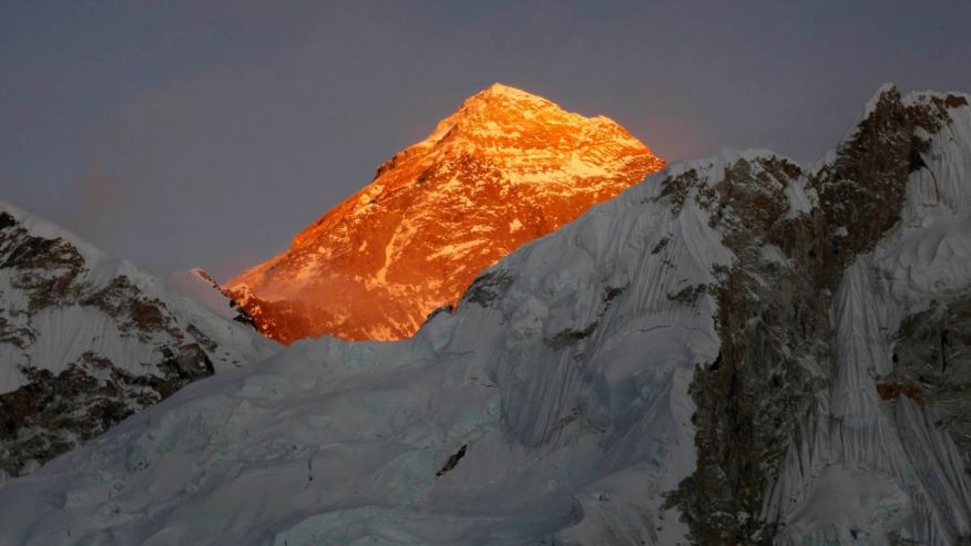
Mount Everest
Mount Everest is the highest peak in the world. With an elevation of 8,848.86 m Mount Everest is one of the most difficult mountains to climb. Located in Nepal and Tibet Mount Everest is also called as Sagarmatha (‘head in blue sky’ or ‘peak of Heaven’) in Nepal. In China it is called as Chomolungma (Goddess of Valley). The third highest Himalayan peak Kanchenjunga lies Partly in India and Nepal.
In the year 1865, The Royal Geographical Society of UK gave Mt Everest its English name in honour of George Everest, a Welsh surveyor who worked as the British Surveyor General of India from 1830 to 1843.
The height of Mount Everest was first published in 1856, when it was known as Peak XVI. In 1953 the first successful ascent to the summit of Mount Everest was achieved by New Zealander Edmund Hillary and Nepali sherpa Tenzing Norgay. From 2005 - 2010 there was an argument about the exact height.
China claimed that it should be measured based on the height of bare rocks which stood at is 8,844m. While, Nepal claimed that the height of Mount Everest should be measured based on the height of snow, which stood at 8,848m. Finally an agreement was reached between two countries saying that height of Mount Everest is 8,848m.
In the year 1802, the British began to conduct survey on India to know the locations and the names of the highest peaks. The survey was called as Great Indian Trigonometric Survey. In the year 1847, Andrew Waugh, a British surveyor, made many survey and finally concluded that Kanchenjunga was the highest peak of Himalayas. However in the year 1852, an Indian mathematician/ surveyor by name Radhanath Sikdar from Bengal identified Everest as the highest peak by using trigonometric calculations.
Geology of Mount Everest
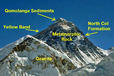
The geology of Mount Everest is very simple. The mountain consists of sedimentary rocks that were under Tethys Sea. The sedimentary rock layers of Mount Everest are limestone, marble, shale, and pelite underneath them are older rocks including granite, pegmatite intrusions, and gneiss. Mount Everest is composed of three distinct rock formations. Each formation is separated by faults called as detachments. From the mountain base to the summit one can notice the Rongbuk Formation, the North Col Formation and the Qomolangma Formation.
Base formation of Mount Everest is Rongbuk Formation. This formation is made up of rocks like schist and gneiss with numerous sills and dikes. These rocks are high grade meta-sedimentary rocks. In short this formation acts as the foundation of Himalayas and extend up from mean sea level to about 7,000m above mean sea level.
The North Col Formation is located between 7,000m and 8,600m above mean sea level. The upper 400 meters forms the famous ‘Yellow Band’, a yellowish brown rock band of marble, phyllite with muscovite and biotite and semischist, a slightly metamorphosed sedimentary rock.
The band also contains fossils of crinoid ossicles, a marine organism with a skeleton. Below the Yellow Band are more alternating layers of marble, schist, and phyllite.
The lower 600 meters is composed of various schist formed by metamorphism of limestone, sandstone, and mudstone. At the bottom of the formation is the Lhotse detachment, a thrust fault that divides the North Col Formation from the underlying Rongbuk Formation.
The Qomolangma Formation, the highest rocks on the summit pyramid of Mount Everest, is formed by layers of ordovician-age limestone dolomite, siltstone, and laminae. The formation starts at 8,600m at a fault zone above the North Col Formation and ends on the summit.
The upper layers have many marine fossils, including trilobites, crinoids, and ostracods. Mount Everest is like a triangular pyramid shape. The flat planes on the three sides are called as faces and the line by which the two faces join is called as ridge.
Flora and fauna
  |
  |
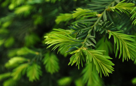
In the lower forested zone, birch, juniper, blue pines, firs, bamboo and rhododendron grow. Above this zone all vegetation are shrubs. As the altitude increases, plant life is restricted only to lichens and mosses above 5,750m plant life ceases as it is completely covered by snow throughout the year.
The Sagarmatha National Park is one of the most beautiful places, especially in summer. After the first monsoon rains in June, different kinds of plant grow rapidly. The hillsides become green and different varieties of flowers start blooming, and butterflies of myriad species appear in different colors.
Due to the presence of insects in the environment, many kinds of birds are also seen in the National Park. 118 species of birds and 26 species of butterflies have made this park their home.
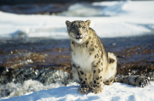
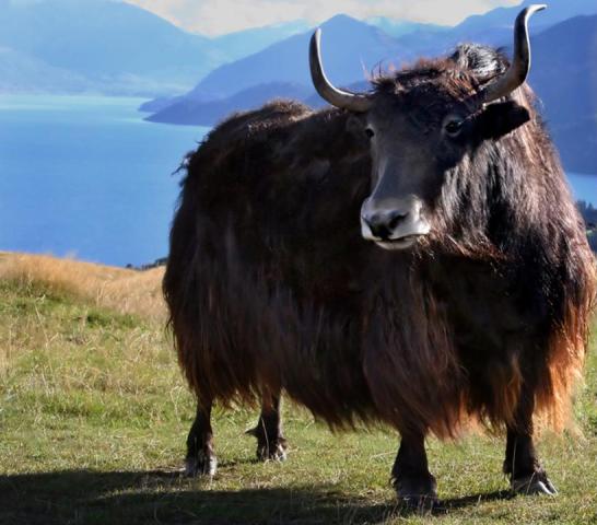
Some of the endangered animals that are found in this park are musk deer, wild yak, red panda, snow leopard and Himalayan black bear. Besides, many other animals such as Himalayan thars, deer, langur monkeys, hares, mountain foxes, martens, and Himalayan wolves are found in the park.
Climbing Routes
 |
 |
Climbing routes
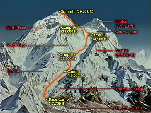
There are two main routes to climb Mount Everest. One of the routes is Southeast ridge route from Nepal and another is North ridge route from Tibet. Apart from these two routes there are numerous routes which are less frequently used. Of these two main routes, the Southeast ridge is technically easier to ascent.
Edmund Hillary and Tenzing Norway climbed the Mount Everest from this route as the other route was not accessible to westerns as China had invaded Tibet in 1950’s.
Climb through Southeast ridge
The ascent from the Southeast ridge start from the base camp at 5,380m which is on the southern side of the Everest. Climbers are made to spend few weeks in the base camp to get acclimatized to the altitude. During this period some of the experienced sherpas and few other climbers set up ropes and ladders for further trek. The climb from base camp at 5,380m involves following steps:
Step 1: Reach base camp at 5,380m
Step 2: Reach camp 1 at 6,065m which is located after the Khumbu ice fall
Step 3: Reach camp 2 at 6,500m which is located at Western cwm. This is also called as Advanced Base Camp (ABC). Western cwm is a generally a flat landscape with gently raising slope. Due to this flat landscape the place is quite warm and silent and hence this is also called as valley of silence
Step 4: Reach camp 3 at 7,470m which is located at Lhotse face and is located on a small outcrop of the mountain.
Step 5: Reach camp 4 at 7,920m which is located at South Col. While climbing to camp 4 from camp 3 the climbers have to navigate two specific challenges namely Geneva Spur and Yellow Band. Geneva spur is an anvil shaped black rock and fixed ropes assist climbers overcoming this climb. Yellow band is layers of marble and other rocks. Yellow rock is also climbed by the use of long fixed ropes.
Step 6: Reach summit or the peak of Mount Everest at 8,848m. The climb from camp 4 onwards is called as ‘death zone’. The climatic conditions that prevail above this altitude (more than 7,920m) is not conducing for human living.
Humans can sustain this harsh climate for a maximum of 2 to 3 days. So depending on the weather conditions, the climbers would take a decision either to attempt to carry on further climb and reach the peak of Mount Everest or to call of the climb and return all the way back to base camp
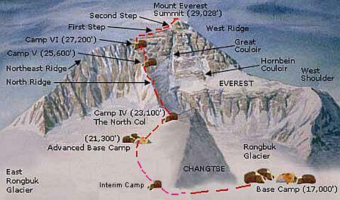
Climb through North ridge
The North ridge base camp begins from the Northern side of Everest in Tibet. This route is less popular compared to South-Eastern ridge route. Climb in this route involves following steps:
- Step 1 - Climbers trek to the Rongbuk Glacier to set up a base camp at an altitude of 5,180m just below the glacier.
- Step 2 – Reach camp 2 at 6,100m. From Rongbuk Glacier to reach base camp 2 one has to ascend east of glacier upto Changtse
- Step 3 – Reach camp 3 at 6,500m situated below the North Col. Camp 3 in this case is also called as Advance Base Camp (ABC)
- Step 4 – Reach camp 4 at 7,100m which is located above the North Col. Fixed ropes are used to reach camp 4.
- Step 5 – Reach camp 5 at 7,775m which is located at rocky North ridge.
6. Step 6 – Reach camp 6 at 8,230m which is located at the base of Yellow Band.
7. Step 7 – Climbers go for the final summit push from . From here climbers face a treacherous task. The climatic conditions that prevail above this altitude (more than 7,920m) is not conducing for human living.
Humans can sustain this harsh climate for a maximum of 2 to 3 days. So depending on the weather conditions, the climbers would take a decision either to attempt to carry on further climb and reach the peak of Mount Everest or to call of the climb and return all the way back to base camp.
Climbers go for the final summit push in ‘three steps’. Any climber who wants to climb the Mount Everest from this ridge must deal with these three steps.
The altitudes of these 3 steps are 8,564 m, 8,610m and 8,710m. The second step is very important in terms of history and mountaineering. The First Step consists of big and huge boulders which causes a serious threat even for experienced climbers.
The Second Step is the best known as the rocky steps. In the second step a climber has to climb at least the last five step vertically due to its steep angle. The step was climbed for the first time in 1960 by Wang Fuzhou, Gongbu, and Qu Yinhua.
The climbing difficulty of this spot was reduced in 1975 when a Chinese team fixed a ladder to these steps which is now used by all the climbers. The third step is easier to climb. After climbing for 10m summit snow field is reached.
Facts for Climbing
Logistics for the climb
Mount Everest climb would at least
require two – three months. Overall cost may be upto USD 60,000. It may vary slight depending on the route
taken. The South ridge route is slightly
more expensive compared to North ridge route.
The guides (famously known as Sherpas) take care of food, fuel and other
requirements needed during the ascent. They also help in getting the permits
required for climbing.
1. Permits: Obtaining permits from the respective governments is mandatory. Depending on the route chosen the permits have to be obtained either from Nepal or Tibet Government.
Update on coronavirus in India
2. Cost involved: Overall cost may be upto USD 60,000. It may vary slight depending on the route taken. The South ridge route is slightly more expensive compared to North ridge route. Following are covered in this overall cost:
Climbing permits: 11,000 USD
Other climbing fees: 1,500 USD
Travel to base camp: 4,000 USD
Sherpas: 5,000 USD
Maintaining campsite: 2,000 USD
Bottled oxygen: 3,700 USD
Gear: 7,000 USD
Miscellaneous: 10,000 USD
Please note: All these may change.
Affiliate Disclosure:
If you make any purchase via a link on this site, I may receive a small commission with no added cost to you.
More touristic places
Goa
Travel Delhi
History of Delhi
Rajasthan
Jaipur
Jaisalmer
Nainital
Jim Corbett
Kamet
Kanchenjunga
Nanda Devi
Sam sand dunes
Taj Mahal
Skiing
India Gate
Lajpat Nagar Market
Lodhi Garden
Lotus temple
Places around Delhi
Connaught place
Purana Qila
Red Fort
Humayun tomb
Safdarjung tomb
Qutb Minar
Jama Masjid
Bangla Sahib Gurudwara
Chandni Chowk
Rashtrapati Bhavan
River Rafting
Check here for Beautiful designer wear Designs
Recent Articles
-
Agumbe --- |Karnataka| | Waterfalls| |Western Ghats |Tourism|
Mar 31, 25 05:56 AM
 Agumbe is a beautiful serene village located in west coastal region in Shimoga district,Thirthalli taluk in Malnad region of Karnataka, India.
 -
Belur Chennakeshava temple, Karnataka, India
Mar 31, 25 05:53 AM
 Belur is world famous for the Chennakeshava temple built during Hoysala period. Belur is also known as Velapura
 -
Badami Cave Temples, History, How to Reach, Best Time to Visit
Mar 31, 25 05:48 AM
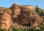 Badami is located in Bagalkot district of Northern part of Karnataka. The place is world famous for the cave temples built during the Chalukya period.
Reach us on and share your feed back on
contact us
Popular pages
Indian art, Indian architecture, Religions of India, culture of India, History of India, Tourism in India, Yoga, ancient India, Indian Music, Indian Dance, India Independence Movement, Indian Dynasties, Ayurveda, Indian Folktales, Geography of India, National Parks in India, National Symbols of India